Today Sinhagad Road reads as one continuous suburb from Rajaram Bridge to Khadakwasla. Within living memory it was a road through farmland, linking a string of villages to the city at one end and to a dam, a fort and a military academy at the other. This is a dated account of how that changed, drawn from public records and reports.
A road to a dam, a fort and an academy
The far end came first. The original Khadakwasla dam was built between 1869 and 1879. The National Defence Academy, north-west of the lake, had its foundation stone laid by Jawaharlal Nehru on 6 October 1949 and was formally commissioned on 7 December 1954. The fort is older than both, and gave the road its name. These dates are from Wikipedia’s entries, consulted in November 2026.
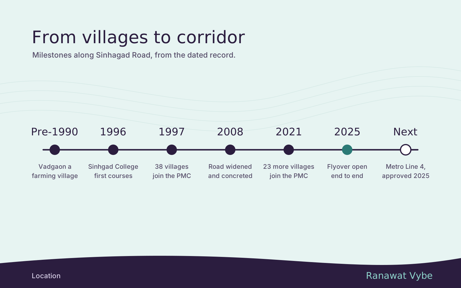
The villages in between stayed rural for a long time. Wikipedia’s entry on Vadgaon Budruk describes it before 1990 as a small village that lived mainly by farming, and a halt on the routes shepherds used to bring their flocks inland from the Konkan. It dates the real transformation to after 2005, when much of the forest and farmland was turned into housing complexes as Pune’s population grew.
The institutes arrive
The first large change on the corridor was educational. The Sinhgad Technical Education Society was registered on 6 July 1993, and Sinhgad College of Engineering, at S. No. 44/1, Vadgaon (Bk), off Sinhgad Road, started its first engineering courses in the 1996 to 1997 academic year, according to the college’s own mandatory disclosure for 2025 to 2026. That disclosure lists a sanctioned intake of 1,140 undergraduates and 150 postgraduates a year.
A campus of that size brings hostels, paying-guest houses, eateries and a steady rental market with it, and the corridor still has that student character. The guide to renting out a flat here looks at that market as it stands today.
From villages to the city
The legal change came in stages. The Pune Municipal Corporation’s draft development plan for its newest areas, published in October 2025, sets out the sequence.
| Date | What happened | Sinhagad Road names |
|---|---|---|
| 11 September 1997 | A state notification added 38 villages to the PMC | Included part of Dhayari |
| 17 November 2001 | The state took 15 villages out entirely and 5 in part | That part of Dhayari left the PMC again |
| October 2017 | Nine fringe villages were brought back in | Dhayari (remaining part) |
| 30 June 2021 | Another 23 villages joined, taking the PMC to 484.26 sq km | Narhe, Nanded, Kirkatwadi and Khadakwasla, among others |
The 2021 village names come from the state’s list as published in December 2020 by the Free Press Journal and The Bridge Chronicle. The plan also notes the cost of the earlier back and forth: while those villages sat outside the corporation from 2001 to 2017, unplanned building carried on. Vadgaon’s own date is harder to pin down. In a pre-election report in January 2026, the Free Press Journal quoted locals saying Vadgaon Budruk and Dhayari had been municipal areas for over a quarter of a century. That points to 1997, but neither the paper nor the PMC plan lists the Vadgaons by name. The guide to the two Vadgaons covers their civic status today.
The timing matches the city’s wider growth. The same PMC report notes that Pune’s population grew fastest in the decade from 1991 to 2001, the years in which the first merger happened and the Sinhgad engineering college opened. Services followed the boundary out. In July 2022 the PMC opened a fire station on Sinhagad Road at Vadgaon Khurd, which Punekar News said would cover the road from the Wadgaon flyover bridge to Khadakwasla, past Kirkatwadi. Both Kirkatwadi and Khadakwasla had joined the city only the year before.
The newest areas are still catching up on planning. The regional authority, PMRDA, published the first draft plan for the 2021 villages in July 2021. In June 2026 the PMC’s City Improvement Committee approved starting a fresh development plan for them, Punekar News reported, to set aside land for roads, amenities and open space.
Townships, a wider road and a flyover
As the villages filled, the scale of building grew. Nanded City, a 700-acre township on what had been the farmland of Nanded village, began construction in 2010, according to Wikipedia.
The road kept pace only for a while. It was widened and concretised under the Jawaharlal Nehru National Urban Renewal Mission in 2008, Punekar News recalled in January 2025, and traffic soon outgrew it. That report named five junctions as the main choke points: Vitthalwadi, Hingne, Santosh Hall, Manik Baug and Ganga Bhagodaya Society. The answer was a flyover built in three phases. The first, 520 m long at Rajaram Bridge chowk, opened in August 2024; the 2.1 km run from Vitthalwadi to Fun Time followed on 1 May 2025; and the last stretch, between Goyal Ganga Chowk and Inamdar Chowk, opened on 1 September 2025. The whole job cost about ₹118 crore.
What comes next
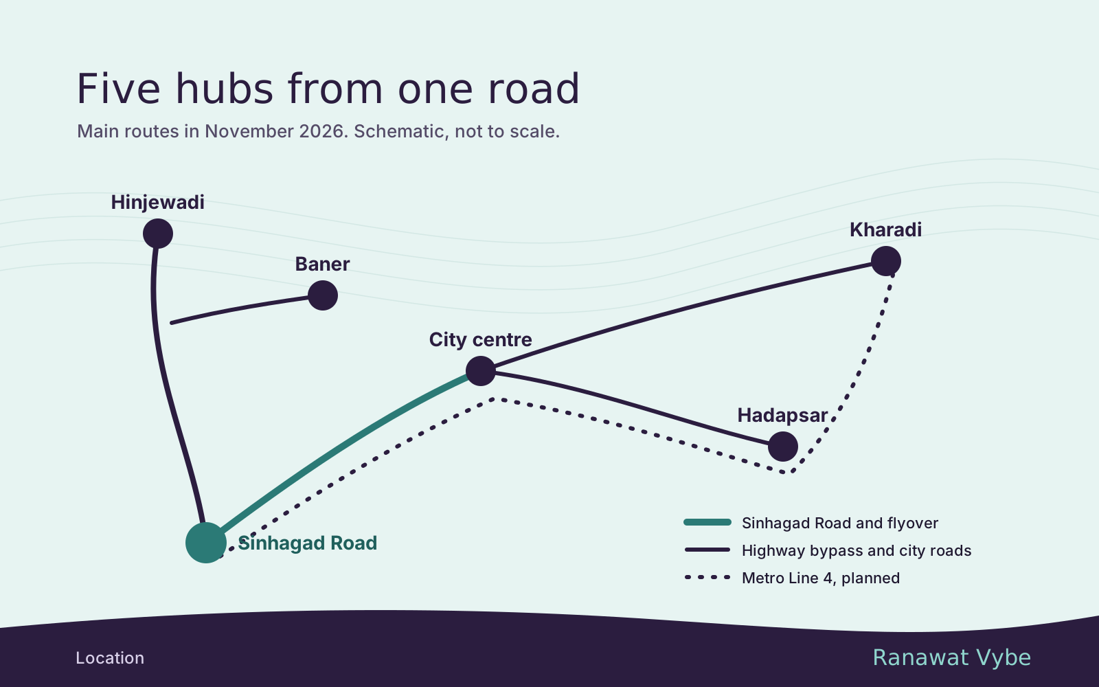
- Metro. On 26 November 2025 the Union Cabinet approved Line 4, from Khadakwasla along Sinhagad Road to Swargate, Hadapsar and Kharadi, together with its spur, Line 4A. By June 2026 Maha Metro was choosing contractors for the stretch along this road. Stations have not been announced, and the line is years from opening.
- A new river crossing. The Suncity to Karvenagar bridge was expected to open in January 2027, The Bridge Chronicle reported in October 2026.
- Planning for the outer villages. The fresh development plan for the 2021 villages will shape the roads and public land from Narhe to Khadakwasla.
Across three decades the pattern has held: colleges and people arrived first, and roads and planning followed. Both developers behind Codename Vybe already have projects on this stretch, as the developer page sets out, and the corridor as it stands in 2026 is summed up on the location page.
To see where the project sits in this story, ask us for the exact location.